1.
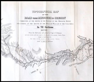
Topographical Map of the Road From Missouri To Oregon Commencing at the Mouth of the Kansas in the Missouri River and Ending at the Mouth of the Wallah Wallah in the Columbia
Washington: 1849. Very good. Lithograph map in seven sections, with each sheet measuring approximately 15.5 x 25 inches. Not bound. Second issue of this monumental and important map of the Oregon Trail, described by Wheat as "a road guide for Oregon emigrants such as had never previously existed." The second..... Item #22103